
Fichier:PIA09183 Titan north polar lakes.jpg
Fichier d’origine (960 × 712 pixels, taille du fichier : 250 kio, type MIME : image/jpeg)
Ce fichier et sa description proviennent de Wikimedia Commons.
Description
| Description |
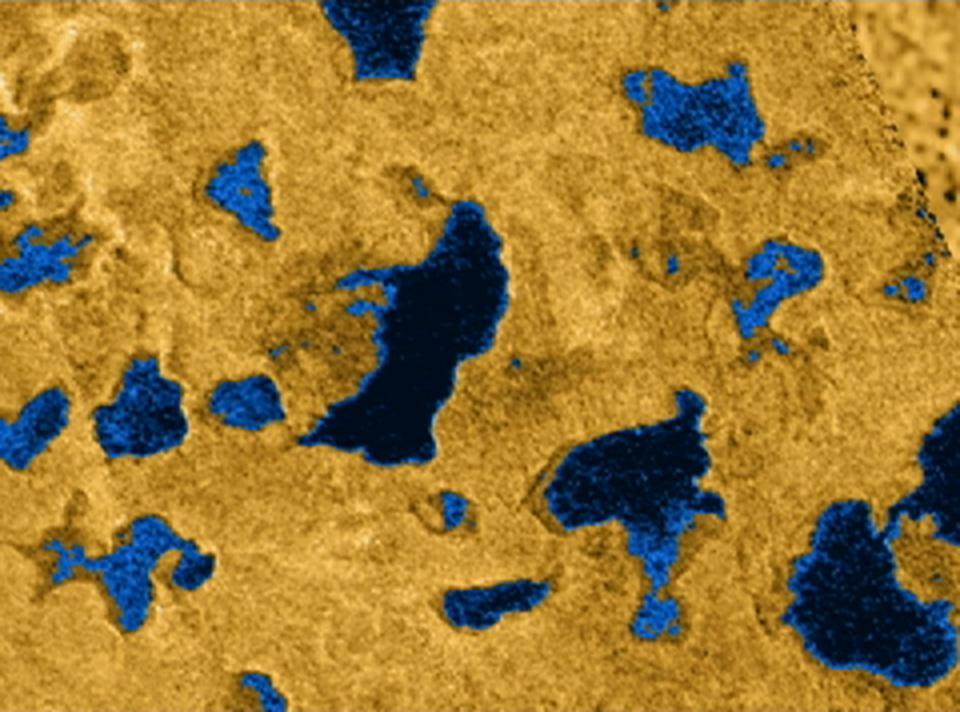
English: This image shows bodies of liquid near Titan's north pole. Many of the features commonly associated with lakes on Earth, such as islands, bays, inlets and channels, are also present on this cold Saturnian moon. They offer strong evidence that larger bodies seen in infrared images are, in fact, seas. These seas are most likely liquid methane and ethane.
For more than two decades, scientists have debated whether liquids on Titan exist, and if so, where they would be located. Pre-Cassini observations from the 1980s indicated that something on Titan's surface must be re-supplying the methane to its atmosphere. A global ocean was once hypothesized. Subsequently, disconnected lakes or seas were predicted. The discovery of numerous lakes near Titan's north pole by the Cassini radar instrument in July 2006 has confirmed the latter idea, and indicates an apparent preference during the current season for liquids to be located near the north pole. These new observations of the north polar area show how extensive and widespread these lakes are, and reveal at least one body of liquid (not pictured) that might rightly be called a sea. These seas cover an area about 100,000 square kilometers (about 39,000 square miles), larger than the largest Great Lake, Lake Superior, near the U.S. and Canadian border, whose area is 82,000 square kilometers (about 32,000 square miles). Analysis of the data indicates that the bodies of liquid may be tens of meters in depth. This image is part of a mosaic of Titan's north polar area just as Cassini radar saw it. The mosaic combines radar swaths seen on several Titan passes: July 22, 2006 (T16); Sept. 23, 2006 (T18); Oct. 9, 2006 (T19); and Feb. 22, 2007 (T25), respectively. It reveals the extent of the lakes, their shapes and interconnections. The areas believed to be composed of liquids are shown in blue as an aid to interpretation. The lakes take many complex shapes. Some features that resemble lakes with no liquid may be remnants that have already dried as the northern winter fades into spring. The resolution of the radar data varies from several kilometers to as fine as 300 meters (984 feet). The Cassini-Huygens mission is a cooperative project of NASA, the European Space Agency and the Italian Space Agency. The Jet Propulsion Laboratory, a division of the California Institute of Technology in Pasadena, manages the mission for NASA's Science Mission Directorate, Washington, D.C. The Cassini orbiter was designed, developed and assembled at JPL. The radar instrument was built by JPL and the Italian Space Agency, working with team members from the United States and several European countries. For more information about the Cassini-Huygens mission visit http://saturn.jpl.nasa.gov/home/index.cfm. The original NASA image has been modified by cropping slightly and doubling the linear pixel density. Some of the features in this image have been annotated in Wikimedia Commons. North is to the lower right. |
| Date | |
| Source | http://photojournal.jpl.nasa.gov/catalog/PIA09183 |
| Auteur | NASA / JPL-Caltech / Italian Space Agency |
| Autres versions |
|

Cette image ou vidéo a été cataloguée par le Jet Propulsion Lab de la National Aeronautics and Space Administration (NASA) des États-Unis sous Photo ID : PIA09183.Ce bandeau n’indique rien sur le statut de l’œuvre au regard du droit d'auteur. Un bandeau de droit d’auteur est requis. Voir Commons:À propos des licences pour plus d’informations. Autres langues :
|
Conditions d’utilisation
| Ce fichier provient de la NASA. Sauf exception, les documents créés par la NASA ne sont pas soumis à copyright. Pour plus d'informations, voir la politique de copyright de la NASA. | ||
 |
Attention :
|
| Annotations | Cette image est annotée : Voir les annotations sur Wikimedia Commons |
Historique du fichier
Cliquer sur une date et heure pour voir le fichier tel qu'il était à ce moment-là.
| Date et heure | Vignette | Dimensions | Utilisateur | Commentaire | |
|---|---|---|---|---|---|
| actuel | 3 novembre 2013 à 05:16 | | 960 × 712 (250 kio) | WolfmanSF | User created page with UploadWizard |
Utilisation du fichier
Les 4 pages suivantes utilisent ce fichier :
Usage global du fichier
Les autres wikis suivants utilisent ce fichier :
- Utilisation sur it.wikipedia.org